BBC News
BBC Weather
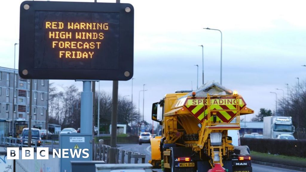
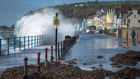
Red weather warnings are in force with millions of people urged to stay at home as Storm Éowyn batters the UK.
Northern Ireland and parts of Scotland are experiencing the worst of the weather and have been issued with the red warnings – meaning there is a danger to life from high winds.
Wind gusts of up to 93mph (150km/h) were recorded at Aberdaron, north Wales, on Friday, while the Republic of Ireland saw its strongest winds ever recorded and has more than 700,000 properties without power.
Schools are closed in Northern Ireland and much of central Scotland, while flights, buses and trains have been cancelled.
Away from the areas expected to be worst-hit by Storm Éowyn – pronounced AY-oh-win – amber and yellow warnings for both wind and rain have been issued, with 11 covering the country.
Red is the most serious weather warning the Met Office can issue, meaning dangerous weather is expected and people are urged to take action to keep themselves and others safe.
The red warning for the whole of Northern Ireland came into force at 07:00 GMT – affecting the morning rush hour – and continues until 14:00 on Friday. Another one covering Scotland’s central belt – including Edinburgh and Glasgow – has been issued from 10:00 GMT until 17:00.
At least 334 flights have been cancelled across airports in Aberdeen, Belfast, Edinburgh and Glasgow, affecting around 50,000 passengers, the PA news agency reported.
Jake Kelly, from Network Rail, said no trains were running in the worst affected areas on Friday, including the whole of Scotland, as well as north of Preston on the west coast mainline in England. There will also be no trains running north of Newcastle on the east coast mainline from 11:00 GMT.
Mr Kelly told BBC Breakfast: “We expect a large amount of debris to be flying around and potentially trees to fall over. It wouldn’t have been the right thing to do to put customers into that environment.
“It’s always a very, very difficult decision to close the railway but in the face of this very extreme weather, ultimately we had no choice.”
Mr Kelly said it was “extremely rare” to close the rail network across such a vast area and it was only done in the “most exceptional circumstances”.
He added that he hoped lines would reopen on Saturday morning but “we simply don’t know the amount of damage we’ll sustain”.
 PA Media
More than 93,000 homes and businesses are without power in Northern Ireland after “widespread damage” to the electricity network, NIE Networks said.
Bus and train services have been suspended there, while all schools have been advised to close and Belfast International airport is warning of significant disruption to flights.
In a message to customers, supermarket chain Tesco said all its shops in Northern Ireland are closed on Friday – adding that home deliveries would be cancelled too.
The Police Service of Northern Ireland said the storm was an “exceptional weather event” and was expected to bring the strongest winds experienced in the region since 1998.
The Irish Republic’s weather service Met Éireann has also issued severe red weather warnings amid the potential for “hurricane force winds” – with BBC Weather also saying it could be Ireland’s storm of the century.
There are 715,000 premises without power in the Republic of Ireland, according to the Electricity Supply Board (ESB), which said there was “unprecedented, widespread and extensive damage to electricity infrastructure”.
It will take a “significant number of days” to restore power to all affected customers, ESB added.
A red weather warning has also been issued for the Isle of Man due to “violent storm force winds”, which is in place until 14:00 GMT.
Ferry operators including Irish Ferries, Stena Line, and Calmac have had to cancel numerous crossings on Friday because of conditions in the Irish Sea and the west of Scotland.
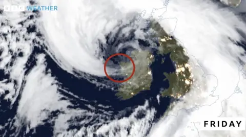
The centre of Storm Éowyn is situated just to the north-west of Northern Ireland.
A core of very powerful winds are battering the west coast of the Republic of Ireland, where a gust of 114mph (183km/h) was recorded at Mace Head in County Galway at 05:00 GMT.
This makes it the strongest recorded gust of wind in Ireland, exceeding the previous record set in 1961 during Hurricane Debbie.
In Northern Ireland, Kilowen, County Down recorded a gust of 92mph at 06:00 GMT.
The storm is due to move east through Friday morning so a red warning is in place across Scotland’s central belt, including its biggest cities Glasgow and Edinburgh, from 10:00 to 17:00.
Schools in at least 20 local authorities – covering most of central Scotland – will be closed on Friday.
ScotRail has confirmed all rail services in Scotland will be suspended on Friday, adding that the closure was to ensure the safety of customers and staff.
Train operators Avanti, LNER, Lumo, CrossCountry, and Grand Central, TransPennine Express and Northern have also issued warnings not to travel in the north of England and north Wales on Friday.
Northern said many of its routes were closed because of the severe weather, with some lines blocked between Manchester and Warrington because of a fallen tree.
The AA urged drivers travelling in red weather warning areas to consider whether a journey is necessary, and if not to postpone it.
 Noreensireland/BBC Weather Watchers
There are 11 UK warnings currently issued:
- red warning for wind for Northern Ireland from 07:00 until 14:00 on Friday
- red warning for wind for Scotland’s central belt from 10:00 until 17:00 on Friday
- amber warning for wind across all of Scotland, north-east England, north-west England and Northern Ireland from 06:00 to 21:00 on Friday
- amber warning for wind across parts of Scotland from 13:00 on Friday to 06:00 on Saturday
- yellow warning for wind across most of the country from midnight until 23:59 on Friday
- yellow warning for rain in parts of Wales, the South West and West Midlands from midnight to 09:00 on Friday
- yellow warning for wind in parts of the Midlands, east of England, London and South East England from 05:00 to 15:00 on Friday
- yellow warning for snow in parts of Scotland, in parts of the North East, North West from 06:00 until 23:59 on Friday
- yellow warning for wind in parts of Scotland from midnight until 15:00 on Saturday
- yellow warning for wind for the western side of England, all of Wales and Northern Ireland and south-west Scotland, from 08:00 until 15:00 on Sunday
- yellow warning for rain for the south-east and south-west, Wales, Midlands, East of England and North West from 08:00 on Sunday until 06:00 Monday
Storm Éowyn is the fifth named storm of the season. It has been caused by powerful jet stream winds pushing low pressure towards the UK and Ireland over the Atlantic Ocean – after a recent cold spell over North America.
‘Weather bomb’
On its journey across the Atlantic, Storm Éowyn underwent a process known as “explosive cyclogenesis” – sometimes called a “weather bomb”.
This term is used to describe an area of low pressure that deepens by at least 24 millibars in 24 hours. Storm Éowyn deepened by 50 millibars in 24 hours – more than double the criteria.
Explosive cyclogenesis is generally a sign of a storm that will bring extremely strong winds with damage and disruption.
It also possible the west coast of Ireland has been hit by a “stingjet”.
This can occur in powerful storms where strong winds higher in the atmosphere are forced to the ground resulting in wind speeds in excess of 100mph.
A stingjet can normally be detected on a satellite image as the hook – or sting in the tail – to the southern side of the storm.
They normally occur as a storm system reaches its most powerful stage and can last for three or four hours bringing the most damaging winds.
During the devastating 1987 storm in southern England it is thought a stingjet was responsible for the strongest gusts. But, in the late 1980s, little was known about the phenomenon and there were no high resolution satellites to help identify them.
